Drift History
The Green River Drift was been
formally listed on the National
Register of Historic Places in
December, 2013.
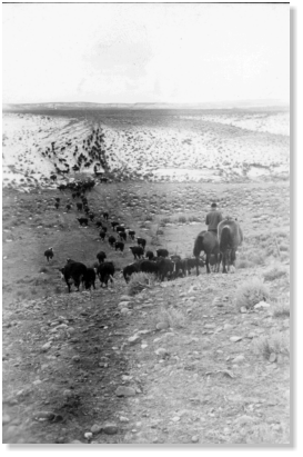
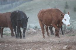
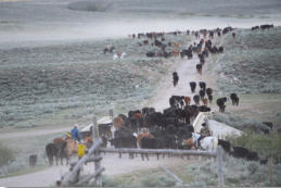
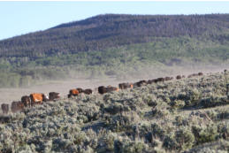
Text below reproduced from the National Register nomination report: http://www.cr.nps.gov/nr/feature/places/12001224.htm History of the Green River Drift Trail The Association uses the Drift to trail its cattle by horse and cowboy with dogs. This trailing follows a specific pattern that has been in place since the beginning of the Drift. Members of the Association own ranches along the southern part of the Drift. These ranches consist generally of ranch headquarters located near major rivers and streams; the headquarters include ranch buildings and irrigated meadows for producing hay and a small amount of grazing and calving pastures. Located further from the headquarters are spring grazing pastures situated mostly on BLM public grazing lands. In the spring, cowboys from each ranch begin moving their cattle north to better summer grazing in the higher elevations of the National Forests. Each ranch has a specific time that they move their cattle up the Drift in the spring, with the ranches located further to the north starting the move first. This process takes about three to four weeks from the middle of June to the middle of July; each ranches’ herd is on the Drift for about two weeks. Once they reach the U.S. Forest Service managed lands, the cattle from all of the herds run in a common allotment through the summer and fall. Less snow on the lower (southern) end of the Drift means that these ranchers calve earlier, therefore, these ranchers turn their bulls out with their cows around June 1 and the bulls are trailed with the cows to the U.S. Forest Service managed property. Upper (northern) end ranchers generally haul their bulls to the allotment and release them with the cows around July 1. The pasturage accessed via the Drift is essential to the ranchers’ operations because of the feed it provides to growing cattle. As the weather begins to turn cold, the cattle “drift” down to lower elevations on their own. Cowboys spend two to three weeks dividing the cattle back into separate herds. The herds are then taken back to the home ranch. Most of the ranchers keep their calves for a year and then sell them the next fall when they are yearlings. This pattern is based on the seasons and has been in place since at least the 1890s. Ranchers rely on the Drift to trail their cattle to crucial pasturage and continue to pass this tradition on to the next generations. After the Equalizer Winter of 1889-1890, the ranchers formed the Big Piney Roundup Association with the goal of keeping the cattle off of the river and creek bottoms, allowing the ranchers to cultivate hay crops. This initiated the beginning of fencing ranches from each other and irrigating fields. The Drift grew out of the creation of the Big Piney Roundup Association and its goal of improved cattle and range management. The purpose and general route of the Green River Drift Trail has remained the same for the last 115 years. The first known use of the Drift took place in 1896, although cattle were grazing above the Bend of the Green River in the 1880s and the Drift may have been utilized prior to 1896. The trail is still used today to get cattle belonging toranches in the area, and particularly, Association members, from the BLM allotments in the area of the Little Colorado Desert to the U.S. Forest Service Allotment. The Upper Green River Cattle Allotment is the largest U.S. Forest Service allotment in the United States, comprising 127,000 acres of the Bridger Teton National Forest. Sublette County Conservation District and Pinedale Natural Resources Conservation Field Office, 2012 Nomination for the Leopold Conservation Award: The Sommers Ranch, More than Just a Legacy, pgs. 2, 9. Use of the Drift began when grazing of public lands in the Green River Valley region was still free and unregulated. Ranchers who belonged to the Big Piney Roundup Association trailed their cattle from the Little Colorado Desert area in what is today southern Sublette County to the good summer grazing lands of the mountains in the northern part of the county. In the beginning, the Churndash Ranch trailed their cattle nearly 150 miles from Fontenelle Creek in what is now Lincoln County to the mountains. In 1906, the first U.S. Forest Service permits and range allotments were established. Ranchers worked with the U.S. Forest Service and the General Land Office/Grazing Service until the BLM formed in 1946. Since that time, the BLM has continually developed range management practices that the Association and other ranchers must follow in order to keep grazing permits on BLM managed lands.JonitaSommers, Green River Drift, A History of the Upper Green River Cattle Association; and James Muhn and Hanson R. Stuart, Opportunity and Challenge, The Story of BLM; andJames G. Lewis, The Forest Service and the Greatest Good, A Centennial History. While the Association must follow BLM’s requirements, the two organizations also work together to accomplish the goals of both.For example, the Association built the first reservoirs along the Drift in the 1930s, but by the 1960s, the BLM alsobegan to participate in the building of reservoirs. In 1963 the Association built four reservoirs on the Mesa and the BLM built two. Just a few years later, in 1967, Hugh Wall, BLM district manager, directed that eleven new reservoirs be constructed on the Mesa. Reservoirs continue to serve an important role today as a place for watering and resting the cattle and horses. Wildlife also use these reservoirs. The Association and the BLM continue to share range management responsibilities with both organizations building or maintaining fences, reservoirs, water wells, and other structures.Upper Green River Cattle Association meeting minutes. Since 1896, ranchers have taken advantage of access to private property that was granted to them by the various property owners along the trail. While approval to cross others’ land was granted, this approval did not exist as a formal agreement until the 1970s and later. The Association obtained the first easement for the Drift in 1970 from Carroll Noble. Since that year, the Association has worked to gain easements for the rest of the Drift from both public and private property owners. The last recorded easement was in 2009.Ranchers that do not belong to the Upper Green River Cattle Association also use the trail to access their summer pastures.JonitaSommers and Albert Sommers Jr. interviews. The Drift main trail is approximately 70 miles long. It trails north off of the Little Colorado Desert and crosses the cattle bridge on the New Fork River which was built in 1945. Before that, the cattle forded the river. The trail goes to the Middle Mesa Well, which is a water well that was drilled and built in 1968 and is used to water livestock. Three spur lines of the trail meet at the Well.From there the trail goes to the Hennick Draw which brings the cattle off the top of the Mesa. The cattle end up on County Road 23-110 (East Green River Road) at the Hennick Place, the headquarters for the Hennick Homestead. Another spur line meets the Drift here. The trail follows the road more or less north to the Drift Fence which is at US Highway 191. The Drift Fence was built in 1921 with WWI wire and the wire is still there today. The Drift Fence is very important in the fall as the staging ground where the upper end ranchers sort their cattle and take them home each day until the cattle are gathered. These cut grounds at the Cora Y represent the point where ranchers tally their losses, gauge their profit based on cattle condition and otherwise assess the success of the year. The lower end ranchers have a cut ground on Highway 351, twenty-two miles south of the Drift Fence. There is an underpass that goes under US Highway 191. The first underpass was built about 1940 when US Highway 191 was built. The Association sent members to Cheyenne to meet with the Wyoming Highway Department to discuss whether or not this would be an underpass or cattle guard. This underpass was rebuilt in 1992 when that portion of US 191 was rebuilt and again the Association commented and maintained communication on where the underpass would be, what time of year it would be constructed, and how it would affect the trailing of the cattle. Upper Green River Cattle Association Meeting Minutes, February 24, 1992 and March 12, 1940. The underpass maintains an important highway crossing for the cattle. In 2011, the Wyoming Department of Transportation is in the process of constructing a wildlife overpass in this same area, the Association continues to be involved in the highway development projects and provides comment. The trail enters the narrow Noble Lane, a 50 foot wide fenced driveway, which was completed in 1971. Carroll Noble granted approval for use in 1940, with an easement being acquired in 1970. The Nobles were the largest private land tract donor and the first to grant an easement to the Association for the Drift Trail. The driveway follows Highway 352 and goes by the town of Cora. The driveway widens some at the Wright or Barlow Hill and stays wide until Marsh Creek. This area provides a place where the cattle can eat and provides access to water at Marsh Creek. The trail goes under Highway 352through an underpass at Marsh Creek. The trail enters the Bloom Driveway, which a crew from the Civilian Conservation Corps built in 1938, going east to the Counting Gate at the Forest boundary. The driveway continues north and comes next to Highway 352 again at the Circle S Dude Ranch. It follows the highway to the end of the pavement and enters U.S. Forest Service managed property. There the cattle enter the forest allotment, but there is still a driveway along the river bottom. The trail follows the road to the Kendall Bridge where the road and trail cross the Green River. The trail follows the road until the Red Gate at Wagon Creek. This is where the Fish Creek pasture system and Mosquito Lake pasture system start.JonitaSommers, personal correspondence, 8/25/2009. In addition to the Association members, the Drift is used by other area ranchers to access summer and fall grazing pastures. Many of these ranchers have also used the Drift for generations. They coordinate with the Association to be sure that the cattle from different herds do not mix.Albert Sommers, Jr. and Charles Price interviews. The Drift is also used by recreational horse-back riders, snowmobilers, dog- sledders, and more. The Association has always tried to maintain a good relationship with other users. In 1982, when planning to build cabins for the cowboys on the Forest, the Association voted to leave the cabins unlocked and ask the skidoo club to watch them and use them if it needed. Association meeting minutes, June 2, 1982.
Period of
Significance,
1896 to Present
The period of significance begins in 1896, with the first documented use of the Green River Drift Trail and ends in the present. The Green River Drift Trail continues to be used as a traditional cultural property and the period of significance reflects the stability of the tradition of trailing cattle along the Green River Drift Trail and its continuing significant role in the agriculture industry of the region.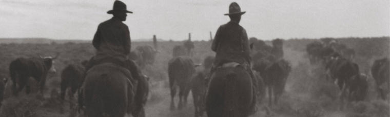


Green River Drift
Photos courtesy Upper Green River
Cattle Association